June 13, 2013 Update
AP&T Surrenders Permit for Connelly Lake Hydro Project in Upper Chilkoot Watershed
Excellent News for Keeping Chilkoot Watershed and its Wild Fish Stocks Sustainable
Chilkoot Watershed Coalition
Sustainable Wild Salmon/Sustainable Communities
June 13, 2013 Update AP&T Surrenders Permit for Connelly Lake Hydro Project in Upper Chilkoot Watershed Excellent News for Keeping Chilkoot Watershed and its Wild Fish Stocks Sustainable |
 Upper Chilkoot Watershed With Significant Salmon Spawning Grounds |
The Chilkoot River near Haines, Alaska, is a small, highly productive watershed. In its short 20 miles of river (100 square miles of watershed), Chilkoot supports four runs of wild salman--sockeye, pinks, coho, and chum. It is also home to a spring run of hooligan (eulachon), Dolly Varden, bears, eagles, moose, wolves, coyotes, otters, beaver, mountain goats, wolverine, and more. The Chilkoot Watershed Coalition is working to preserve the natural assets of the Chilkoot Watershed for sustainable wild fish stocks and a sustainable economy in Haines, Alaska. Chilkoot supports the fishing and tourism industries, as well as local food gathering and a traditional lifestyle.
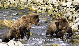 Brown Bear Siblings/Lutak Chilkoot Estuary/Late Summer |
 Chilkoot Lake Winter Reflection |
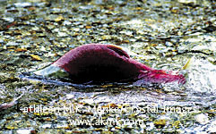 Spawning Sockeye Salmon Bear Creek/Upper Chilkoot |
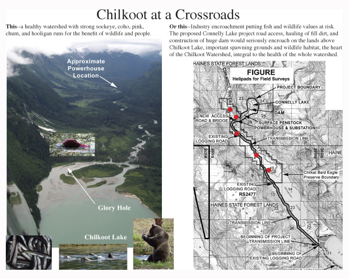
Issues/Threats to the Chilkoot Watershed:The most serious threat to the future sustainability of a healthy Chilkoot Watershed is a proposed hydro-power project, known as the Connelly Lake Project, that would involve constructing a dam at the outlet to Connelly Lake in the upper watershed. Roads and power lines would have to be installed up the left side of Chilkoot Lake and through the sensitive wetland salmon spawning habitat areas above Chilkoot Lake in an area that was set aside as part of the Chilkat Bald Eagle Preserve (diagonally crosshatched area on the map) because of its importance as salmon habitat. The project is proposed to produce 12 megawatts of power.
Comments to FERC were due January 3, 2012. FERC November 2, 2011 announcement with project description: here.
To access submitted documents, go to www.ferc.gov. Click on e-library. Enter docket number P-14229.
Statistics Update, February 18, 2010: According to studies by the Alaska Department of Fish and Game (ADFG) and the Takshanuk Watershed Council, 41% of District 15 (Upper Lynn Canal) sockeye are produced by the Chilkoot Watershed. Of these sockeye, 25% spawn in the sensitive habitat in the upper watershed that is located above Chilkoot Lake. Additional anadromous fish found above Chilkoot Lake in these spawning grounds include a significant number of spawning and rearing coho, Dolly Varden, and even occasional chum salmon. 200 spawning coho were found at the mouth of the outlet stream from Connelly Lake in 2009. The commercial sockeye fishery from Chilkoot Lake is valued at approximately $1 million annually.
News Update, December 2009: The December 3, 2009 issue of the Chilkat Valley News reports that the Lynn Canal Gillnetters Asociation in October passed a resolution that they "prefer the Schubee Lake option over the Connelly Lake proposed development" because "Schubee Lake poses no risk to our local fisheries."
News Update, October 2009: The Alaska Native Sisterhood, Camp #5 of Haines, passed a resolution on September 26, 2009 by a vote of 12-0, in support of protection of the Chilkoot Watershed and in opposition to the Connelly Lake hydro-project. You can read the full resolution HERE.
According to the National Marine Fisheries Services (NMFS) in their Motion to Intervene Connelly Lake Project 2002, "The unnamed creek flowing from Connelly Lake (Alaska Department of Fish and Game Anadromous Stream Catalog #5-33-10200-2016) supports spawning and rearing populations of coho salmon and Dolly Varden char. The Alaska Department of Fish and Game has identified approximately 0.25 miles of anadromous fish habitat within this stream. Besides providing spawning habitat for stocks originating in this reach, this reach provides feeding and resting habitat and refuge for mainstem stocks during periods of high flows and other adverse conditions. The unnamed stream enters the Chilkoot River, which supports migration and spawning of coho and sockeye salmon and Dolly Varden char within the Chilkat Bald Eagle Preserve. The project would require construction of access roads, diversion structures, penstocks, and powerhouse that could result in erosion, stream sedimentation, and increased turbidity. Sedimentation of spawning gravels downstream of the project could reduce egg and fry survival. Construction activities could result in dewatering of fish habitat. Diversion structures could limit or prevent fish migration and passage and result in loss of gravel recruitment that is critical to downstream spawning habitats. Among the potential operational impacts, the project would require impoundment and control of flow regimes. The bypass reach includes habitat used by salmon that are important to the Chilkoot River Fishery. Diversion of water around the bypass reach could result in permanent loss of spawning habitat and loss of anadromous fish populations within this stream. Dewatering of the bypass reach would reduce available habitat used by resident and anadromous mainstem fish populations. Failure to maintain adequate instream flows due to operation of the project could result in dewatering of spawning redds and loss of fish populations within this stream. Construction of a powerhouse at the confluence of the Chilkoot River could result in false attraction of adult salmon migrating to spawning sites. Construction and operation of the project could result in additional impacts to anadromous fisheries that cannot be ascertained from the scoping documents and require the completion of additional studies."
Businesses and Organizations that support the protection of the critical fish and wildlife habitat of the Chilkoot Watershed:
In order to protect traditional lifestyles, sustainable wild salmon runs, and a healthy local economy, the Chilkoot Watershed Coalition supports:
Donate her to support the work of the Chilkoot Watershed Coalition. Donate with your credit card through PayPal using the "Donate" button below.
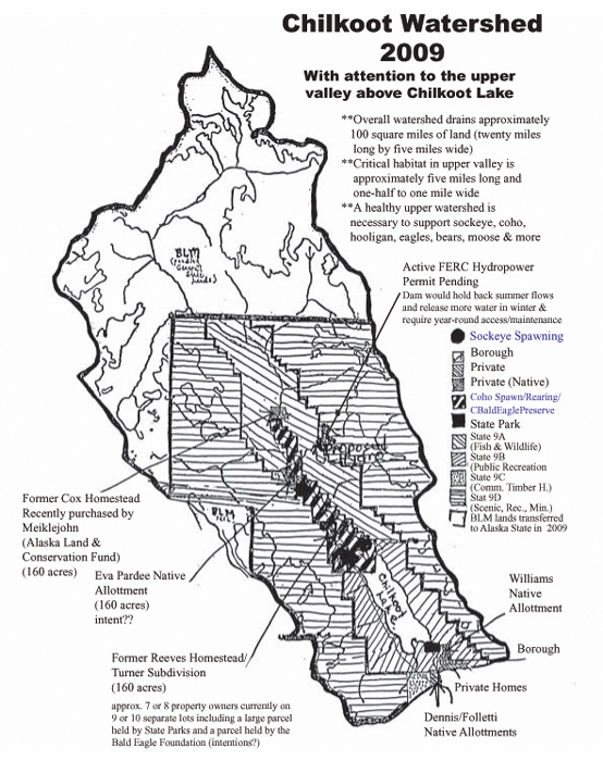
Chilkoot Watershed Land Ownership and Boundaries 2009 showing location of proposed hydro-project and potential development
in conflict with sensitive salmon and coho spawning and rearing grounds, Chilkat Bald Eagle Preserve, and bear and moose habitat.
Lower end is located ten miles north of townsite and four miles north of Alaska Marine Highway ferry terminal, Haines, Alaska.
Entire watershed is public land (now all Alaska State Park and Forest Service lands with the 2009 transfer of BLM lands to the State)
with the exception of a few private inholdings (shown). The watershed above the lake is currently pristine and undeveloped.
This upper valley is the heart of the watershed supporting the salmon runs, eagle nests, and significant bear and other wildlife
habitat which is why the dark cross-hatched area in the center above Chilkoot Lake is designated Chilkat Bald Eagle Preserve.
Comments:
"I was again reminded, after a recent visit to the Upper Chilkoot River on 8/28/09, of the dynamic and productive nature of the Chilkoot River. The river is constantly cutting new channels and abandoning others. Any road constructed in this upper watershed will require large quantities of fill to raise the roadbed and riprap to prevent further migration of the river channels. Besides the significant cost and need to source this material, there will be a significant impact to the hydrology and fish producing capacity of this river system. The small size of this watershed also means that a large amount of high quality fish habitat is condensed into a small area. Making this watershed even more vulnerable to the impacts of road building."
Ben Kirkpatrick, Haines
"The Chilkoot Lake area has been the hub of salmon, wildlife and people for hundreds of years times ten. Our Native people have done natural habitat enhancement by providing special spawning areas along the river and lake. The made sure the salmon were sustainable. My late husband, Pual Wilson Jr., was against any more impact on the Chilkoot River and Watershed, as am I. Once this area is impacted then any mitigation is moot as the damage will already be done. It would be to the benefit of this most sensitive area, the community, the commercial fisheries, our subsistence users plus the wildlife to not impact this area at all. The impact of change in water flow and temperature, new roads, traffic, waste products, and erosion will negatively impact this magnificent habitat. I support a thorough study of the Shubee Lake alternative."
Marilyn R. Wilson, Haines
"I enthusiastically support this endeavor. It's a watershed worth protecting."
Nick Jans, Alaska Author/Publisher
"Chilkoot watershed must be protected for now and future generations."
Carol Tuynman, Haines
"The Denali/San Andreas fault system goes right up through that valley. Geologists are in agreement that it's a bad idea to put a dam up there on the side of that mountain!"
Sally McGuire, Lutak/Chilkoot/Haines
"Once the concrete is poured for a dam for a 12 megawatt power plant that will hold back summer flows and release flows in the winter, then Chilkoot River flows and future will be based on power demand, not on the needs of wild fish stocks. The access road above Chilkoot Lake through the Chilkat Bald Eagle Preserve salmon spawning grounds, wetlands, and critical wildlife habitat will have serious impacts on this watershed. Per square mile, the Chilkoot Watershed is one of the most productive watersheds on the planet."
Kathleen Menke, Haines
An alternative site for a hydro-power project in the Upper Lynn Canal is Schubee Lake, a 300 acre lake located 3300 feet above the eastern shore of Taiya Inlet. It can produce as much power as Connelly Lake with far fewer risks. Schubee Lake had gone unnoticed as a power source until recently. Maps from the 1970�s showed it as mostly covered by a glacier. A lot of ice has gone over the falls in the past few decades as a result of climate change. Development of hydropower at Schubee Lake would be much simpler than at Connelly Lake. There would be no dam and no road. There would be no impact to salmon habitat. The transmission line to connect to the existing grid would be much shorter. The Connelly Lake hydro project has an estimated price tag of $34 million. A Schubee Lake hydro project would likely cost less than half of that amount. The choice seems obvious." Rob Goldberg, Haines
Alaska: The Conservation Fund
Alaska Chilkoot Bear Foundation
Alaska Indian Arts
Alaska Native Brotherhood Camp #5
Alaska Native Sisterhood Camp #5
Alaska Nature Tours
Alaska Wildlife Alliance
Artful Boats
Bell's Seafood
Cloudburst Productions
cstudios
Crystal Images Photography and Publishing
Dejon Delights
Geosemiotics
Lynn Canal Conservation
Moseys Cantina
Natural Channel Design, Inc.
Rainbow Glacier Adventures
Richard Folta, L.L.C.
Seafood Alaska
Sockeye Cycle Co.
Southeast Alaska Conservation Council
Takshanuk Watershed Council
TJ Marine
We the People--Haines, Alaska
Windy Ridge Publishing
Please E-mail Chilkoot Watershed Coalition coordinator, Kathleen Menke, Haines, Alaska, with your comments and suggestions for this site. Statements requested (with permission to post) of what the Chilkoot River and its natural resources mean to you, your family, your business. E-mail
Fisheries/Watershed Credentials/Kathleen M.K. Menke
You do not have to be a member of Paypal to use this option.
Checks also accepted. They should be made out to "Chilkoot Watershed Coalition" and mailed to Chilkoot Watershed Coalition c/o Kathleen Menke, PO Box 781, Haines AK 99827.
This site maintained by Kathleen Menke/Crystal Images with support from the Chilkoot Watershed Coalition network.
Most Recent Site Update: June 2012